|
|
|
Clark County Press, Neillsville, WI February 16, 1994, Page 32 Transcribed by Dolores (Mohr) Kenyon. Index of "Good Old Days" Articles
|
|
|
|
Clark County Press, Neillsville, WI February 16, 1994, Page 32 Transcribed by Dolores (Mohr) Kenyon. Index of "Good Old Days" Articles
|
Good Old Days
A HISTORY OF LOYAL’S CITY AND TOWNSHIPS
By Dee Zimmerman
As settlers proceeded northward into Wisconsin and Clark County during the 1850’s land in the present Township of Loyal was discovered as being very appealing to those seeking homesteads.
Being interested in lumbering, Samuel Weston claimed land in section six, lured by the standings of heavy growth pine and hardwood timber. The hardwoods consisted of white oak, red oak, black oak, white and black ash, birch, maple, basswood and butternut. The first to be harvested were the towering pines with hardwoods going later, hardwoods that would make present day lumbermen feel they had found Utopia.
Beneath the forest cover, was rich and deep soil, adaptable for excellent farmland, to be proven in later years. Many small streams of pure water wound through the forested area, with no swamps.
After Weston, Andrew Sheppard and John Valentine took up sections 3, 4 and 5 with Stephen Amery claiming section 19.
Two early settlers searching for a new homeland, Erastus and Daniel Mack traveled from Canada, after hearing great stories about Wisconsin. As many other frontiersmen, they followed the waterways to Sheboygan County, then made their way westward. They joined a party of men that were surveying a railroad west to the Mississippi. That survey led through what is now the City of Loyal. When the Mack brothers viewed the Loyal area land, they were impressed with its possibilities, their search was over, this, was to be home.
The Mack’s’ chose land along what would be (and still is) known as the “26 Road,” in the year of 1857. The land was purchased for $1.25 per acre from the United States Government. A school building was eventually built on the corner of Erastus Mack’s farmland property. The site was leased to the school district on a 99 year lease at $2.50 per year, a lease that was honored throughout the school’s existence, paid to whom every owned the farm during those years.
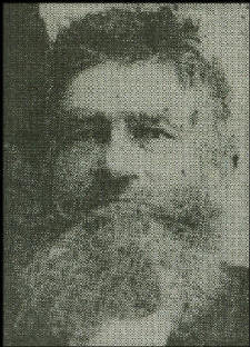 |
ERASTUS MACK
One of the first Loyal area settlers was Erastus Mack, a man who had a will of his own and important trait for a frontiersman. He was influential in the Loyal Township’s development.
Through Mack’s determination, the 26 Road was established. He realized the importance of a good road system for the area settlers and community. After he got the road nominally located, he went to a town meeting to ask for $100 to improve the road. It was refused. He said, “Gentlemen, I stay right here until I get the money.”
He got the money. Pioneers needed such persistence. The 26 road derived that name from to the fact that it was laid out through the row of Townships 26 North. It was also another means of identifying the location for travelers and new settlers who had purchased and coming to find their land. With its history, it seems only fitting that its name has been retained. The 26 Road signs are visible at its crossroads.
Daniel Mack left the area in 1875 when he traded his farm for one in Monroe County, where he lived the remainder of his life.
Other settlers followed the Macks, among them the Lloyds, Hallocks, Bordens, Welsh, Sitts, Hills and Smiths.
A story was told about the Borden family after they had settled on their land. One evening, two of their boys were sent into the woods to find the cows and bring them up to the farmyard. Time passed, darkness came, and the boys hadn’t returned. The parents became alarmed and started into the woods looking for their sons. Soon the boys directed them to where they were. They had climbed up into a couple of trees when a black bear with cubs came after them. The bear remained setting under the trees, seeming to enjoy the boys’ predicament and frightened calls for help. As the parents approached, the mother bear and her cubs took off into the woods.
William Hills, Abram Smith, Henry Sitts and William Welsh came to the area as pioneers wanting to homestead some land. They wanted to be neighbors, so were together out scouting the land when they discovered the quarter stake between Sections ten and eleven. They liked the looks of the land and decided to settle there.
But now, who would get which land quarter? They debated on how to make a fair decision. Finally, as the four of them stood around the quarter stake, each on a different piece of land, they question was asked, “Why not each take the land upon which he is standing?” That question furnished the solution. They all agreed and started for the U.S. Land office in Eau Claire, so as to claim the land.
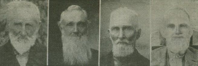 |
WILLIAM HILLS ABRAM SMITH HENRY SITTS WILLIAM WELSH
These four men traveled together seeking land to settle on. When they came upon a quarter stake marker, in the Town of Loyal, they were all in agreement that they had found the land they were looking for. They sat around the quarter stake to eat lunch and discuss who would take which quarter, yet do it fairly. Finally, one suggested, “Let’s each claim the land which we are standing on.” All agreed that was a good solution. They cleared their land, built homesteads and with their families, lived as neighbors for about thirty years. (Photo courtesy of Clark County Historical Society Jail Museum)
In 1866, John Graves and family became the first settlers in what was to be the City of Loyal. He bought land and built the first saw mill in that region. Later he built a flour mill. His son, S. D. Graves, became Loyal’s first merchant, its first post-master and opened the first hotel.
Other early-established businesses were those of A. H. Booth, John and Peter Gwin, T. B. Philpott, Le Claire, Hallock, Oliver hills, G. W. Allen and Elias Weaver.
The first school house, a 16’ by 24’ log building, built in 1873, was on the west side of town. Sara Loop taught the first term and Horace Draper the second term. The log building was used until 1881 when a frame building was erected in its place. Having additions and improvements through the years, the second facility was in use until 1937.
Back in the “early days,” lumber was plentiful and cheap, so farmers built their fences out of boards which today would be classified as number one quality building material. Advertisements were often hand-painted upon the board fences. Two young men came into Loyal, offering their services to do such advertisement painting around the town. One of those young men was James Whitcomb Riley, who later became a renowned and loved poet.
It is believed that Oliver Hill named Loyal. A soldier in the cavalry during the Civil War, he was discharged on a disability. He later re-enlisted in the Infantry, again being discharged because of a disability. It was said the name came to his mind because of his “loyal” fighting for the Union. The name was adopted upon his suggestion.
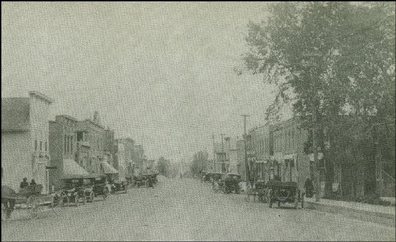 |
Loyal’s Main Street in c.1920: Automobiles as well as the horse and buggies were parked up and down the street. Some of the businesses were McGonigal Hardware, Hal Voigt Meat Market, Fulwiler’s Barber Shop, Jess Raab’s Meat Market, Wavrick General Store, Bill Meyer’s Barber Shop, Dr. Ryan’s office, Fred Adler’s Barbara (Barber?) Shop, Davel’s Store and garage, and the Picus Store. In the middle of the photo, the country road going up the hill is now Highway “K”.
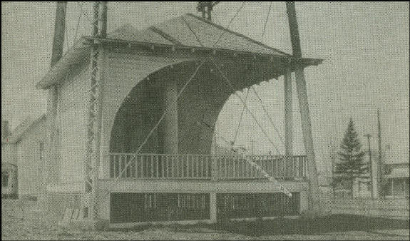 |
The city’s first water tower was located at the corner of South and Main Streets, in the center of a little park. A band shell was cleverly built at the base of the water tower, to be used for the Saturday night band concerts held during the summer months. During the 30’s and 40’s, Saturday night was shopping time for the farm families as well as town residents. It was an evening to socialize, attend the band concert and visit with friends.
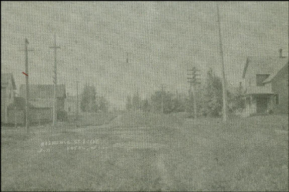 |
Residence Street scene, c. 1915; a typical small town residential street for that era. A Street-light hangs over the intersection held by wires anchored to the electric pole and telephone poles on the corners. A beaten path went up the middle of the street, curb and gutter came many years later. A boardwalk is visible on the right side of the street.
Looking through the county’s history, it is interesting to read each community’s own, unique historical events only a few of many, I’m sure.
|
© Every submission is protected by the Digital Millennium Copyright Act of 1998.
Show your appreciation of this freely provided information by not copying it to any other site without our permission.
Become a Clark County History Buff
|
|
A site created and
maintained by the Clark County History Buffs
Webmasters: Leon Konieczny, Tanya Paschke, Janet & Stan Schwarze, James W. Sternitzky,
|