|
1840 Clark Co. WI State Census This census was contributed by Ken Wood & Janet Schwarze |
|
|
1840 Clark Co. WI State Census This census was contributed by Ken Wood & Janet Schwarze |
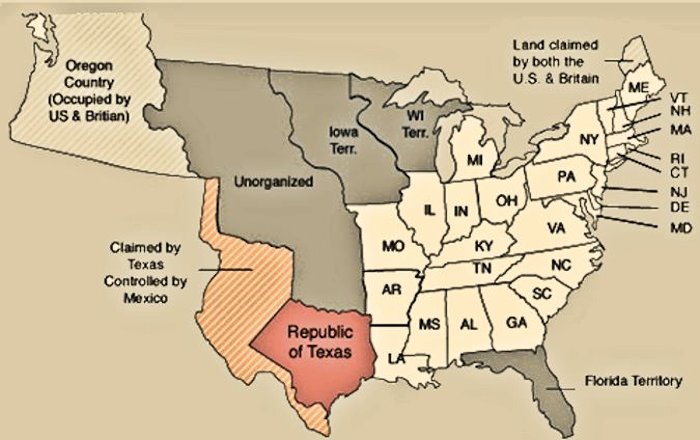
This census was taken when Wisconsin was a TERRITORY of the United States
|
In the early 1800s, the land and streams that are now Clark County were the hunting grounds of Chippewa, Dakota, Ho-Chunk and possibly Menominee peoples. In 1804, the government forced the Sauk and Fox tribes to cede their land claims in southern Wisconsin in a treaty they had not agreed to.8 These actions led to the Black Hawk War of 1832. The largest American Indian population in Wisconsin, the Menominee, was pressured to sell away 11,600 square miles of land along the lower Fox River.9 The 1825 Treaty of Prairie du Chien was significant in the history of American Indians in Wisconsin, after European settlement. The treaty was facilitated by the United States government to end the inter-tribal warfare that was disrupting the fur trade and creating tensions between settlers and the tribes. The tension between tribes was created because the United States government had used them against each other to gain more lands. The Treaty of Prairie du Chien established a treaty of peace among the tribes and demarcated boundaries between settlers and American Indians. In 1836 these Indians were joined by a party of French-Canadian fur traders who started a temporary post for the American Fur Company on the Black River's East Fork.
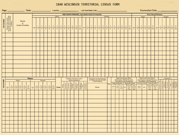
Interesting facts about the 1840 census
|
|
|
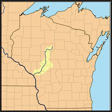
The Black River is a river in west-central Wisconsin and tributary of the Mississippi River. The river is approximately 190 miles long. During the 1840's pine logs were rafted down the Black, heading for sawmills at La Crosse and points beyond.
|
|
|
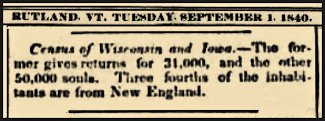
1840--31,000 Wisconsin Residents
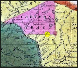
Henry J. Abel, of Wis. Territorial Map Compiled and Engraved by J. H. Young, Philadelphia 1838. Territory of Wis., Est. by Act of Congress. April 10, 1836.. A section of that map shown above is highlighted to show the app. location of what became Clark County, Wis. |
Southport telegraph, August 11, 1840 Southport telegraph. Southport, W.T. [i.e. Kenosha, Wis.] 1840-1850 |
|
|
|
 |
|
|
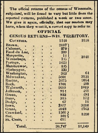
1840 Census Data:
6th United States Census - President: Martin Van Buren
|
|
|
*************************************************************************************** The Records Below Show Individuals who later moved on to Clark County after Wisconsin became the 30th state to be admitted to the Union (29 May 1848). These are provided for researchers who want to follow the flow of settlers into Clark County, WI. If you can add to our list, please contact us.
|
|
| 1840 Wisconsin Territorial Census, Western Division, Iowa | |
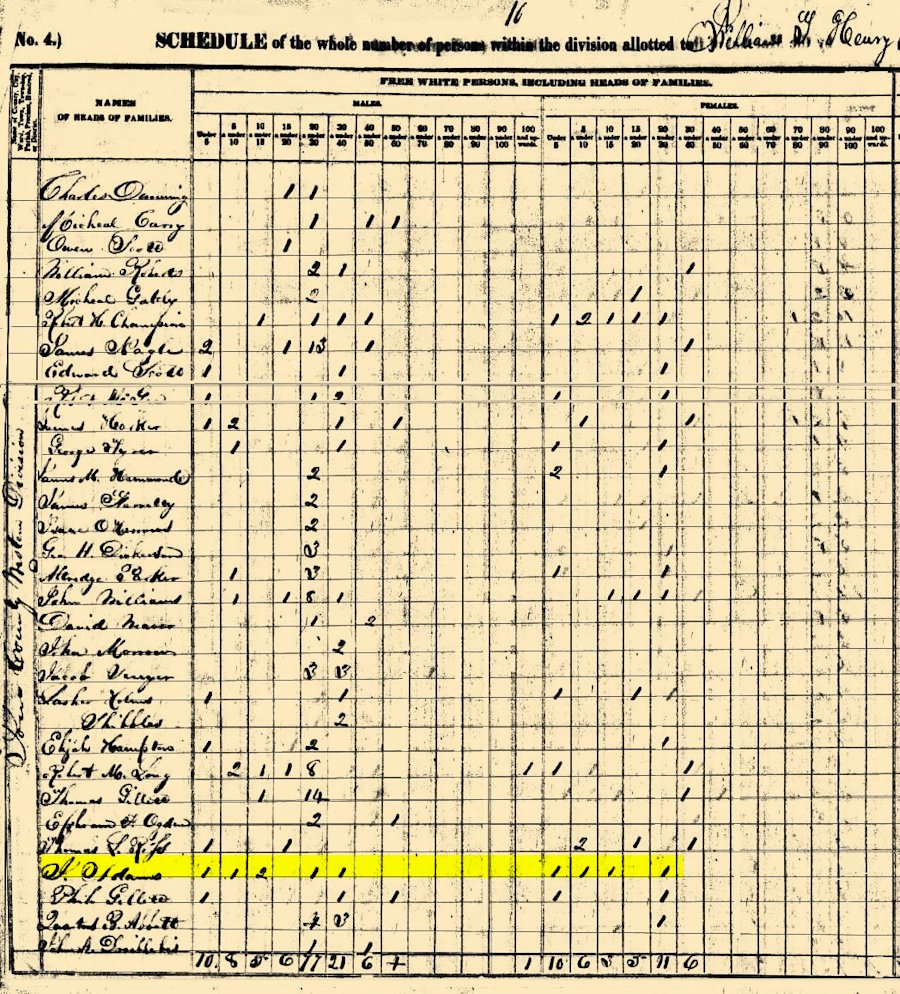
| Index,
1840 Wisconsin Territorial Census, Western
Division, Iowa, pg. 52:
Micheal Carry;
William Roberts;
Robert H Champion;
James Nagle;
Edward Scott;
James Harker;
George Tyrer;
Isaac O Harrows;
Geo H Dickerson;
John Williams;
David Weaver;
John Morrow;
Elijah Hampton;
Ephram F Ogden;
Thomas L Ross;
Philo Gillett;
Quartus B Abbott;
Owen Scott;
James Farrelly;
Thomas Gillett;
Charles Dunning;
Micheal Gately;
Robert McGee;
James M Hammonds;
Altredge Parker;
Jacob Sewyer;
Robert M Long;
J Adams; Shibbles;
Lasher Holms;
John A Dreiblebis Index, 1840 Wisconsin Territorial Census, Western Division, Iowa, pg. 50 John B Terry , J J Nichols , Henry Curtis , John H Sholes , Thomson Hues , Frank Washburn , Henry Jonhault , Aaron Hastings , Benjamin Loughery , Charles Hood , David Gard , John Jacobs , Robert Noble , Charles Pole , A N Drummond , Micheal Darmont , Benjamin Bennett , William Smoot , Charles J Miller , David P Sppofford , Robert C Hoard , Denis Oniell , William Great , Christian A Power , Samuel Woodard , John Curtz , J T Bube , Christopher Young , Andrew Berge , A M Nicoll , Alfred Lanridge |
|
© Every submission is protected by the Digital Millennium Copyright Act of 1998.
Show your appreciation of this freely provided information by not copying it to any other site without our permission.
Become a Clark County History Buff
|
|
A site created and
maintained by the Clark County History Buffs
Webmasters: Leon Konieczny, Tanya Paschke, Janet & Stan Schwarze, James W. Sternitzky,
|