WARNER
is one of the two towns that have the largest
area of any in the county. It extends eighteen
miles east and west, and six miles north and
south, consisting of three townships, which are
described as township twenty-seven, ranges two,
three and four west. It is located a little
northwest of the center of the county. It was
organized by act of legislature passed in the
year 1874. It was named in honor of M.B. Warner,
who was one of the first settlers in the town,
and who is still a resident of the town.
The settlement is principally in the eastern
half of the town; and the population consists
largely of eastern people. This eastern part of
the town has been settled for quite a number of
years, especially along Black river.
There are a large number of small streams,
without names, flowing through the town-enough
to water the surface sufficiently. Black river
flows south through the eastern township. Popple
river unites with Black river in this town, just
above the village of Hemlock. A large flood dam
has been built across Black river at Hemlock,
which is used in flooding or floating logs down
the river, and also in running the mills at
Hemlock. The South Fork of the Eau Claire river
flows through the middle township, and the North
Fork of the same river through the western
township. All of these streams have been used
largely in floating the pine timber, which grew
in the town, to market. The western township was
originally covered with a thick growth of pine
timber. This however, has nearly all been cut,
leaving but very little timber of any value.
The land in this part of the town is not well
adapted to agricultural purposes, and will
probably never be of very much value, unless it
be for pasture or grazing lands. The land in the
western half of the middle township is similar
to that just described, and has a level surface.
The eastern half of this township, or that
portion east of the South Fork, is much better
land, having originally been covered with
hardwood timber, a portion of which has been
cut, and several fine farms started. The eastern
township is also largely hardwood land, and has
been settled for some time. There are some of
the largest and best farms in the county in this
township.
The soil is well adapted to the production of
the various kinds of grains, vegetables and
grasses of this latitude, and stockraising and
dairying is receiving a share of the attention
of the farmers.
The highways and bridges in the town are
numerous and in good repair.
The schools and churches and, in fact, all
public matters receive proper attention, and
testify to the enterprise of the people.
The line of survey of the Wisconsin Central
railroad runs through this town. The road will
be completed this season as far as Greenwood,
which is on the southern boundary of this town,
and next season the road will be completed
through this town to Chippewa Falls or some
point near there.
The proposed line of the Chicago, Milwaukee &
St. Paul railroad also extends through this town
in a northwesterly course. This road is already
in operation as far as the village of Lynn, and
grading is being done on the extension from Lynn
to Thorp. These roads, when competed, will
furnish the town with excellent railroad
facilities, and be very beneficial to the
inhabitants.
The little village of Hemlock, on Black
river, in this town, has two large mills, one
flour mill and one lumber, shingle and lath
mill. The water power, by which these mills are
run, is unlimited here. There is a sufficient
volume and fall to run any number of mills and
factories. Hemlock is the northern terminus of
the telephone line which extends south to La
Crosse, and east to the towns on the Wisconsin
Central line. It is the longest telephone line
in this section of the country.
The census reports for '75, '80 and '85 give
the following figures: Population of the town in
1875, 294; in 1880, 435; in 1885, 590. The
population for 1890 has not yet been furnished
us, but there has been a good increase in the
past five years.
The officers of the town for 1890 are as
follows: Chairman, W.H. Mead; clerk, William
Vollrath; treasurer, Henry Humke; assessor, A.
Larson.
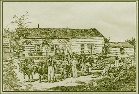
Pioneer Home of Harry Mead.
The above cut represents the pioneer home
of W. H. Mead. Of the town of Warner. The
building was erected in 1866, and served as
the home of Mr. Mead and his family until
the year 1871, at which time he built a fine
large residence. Mr. Mead was born in
Dutchess County, NY, in 1833. He came with
his parents to Jefferson County. Wis., in
1845, where he lived until 1865. He was
married in 1861 and moved to Clark County in
1865 where he engaged in lumbering and
farming
(Source:
CLARK
COUNTY ILLUSTRATED, published 1890 by
Saterlee, Tifft & Marsh - pages 53-54)
Transcribed
by Carol Awe