Maps of Thorp Township, Clark Co., WI


ALHN HOME PAGE

Cemeteries

Plat Map Project

Our Businesses

Changing Times Churches

Community Life

Families & Homes

Local Histories

Memories & Letters

The Local News

Organizations

Pictures & Postcards

Our Schools

Tragedies


All Transcriptions for this project have been contributed by Paul Forster.
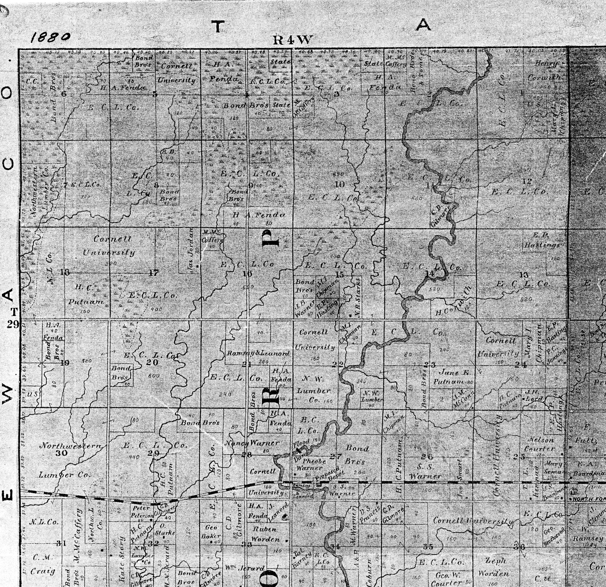
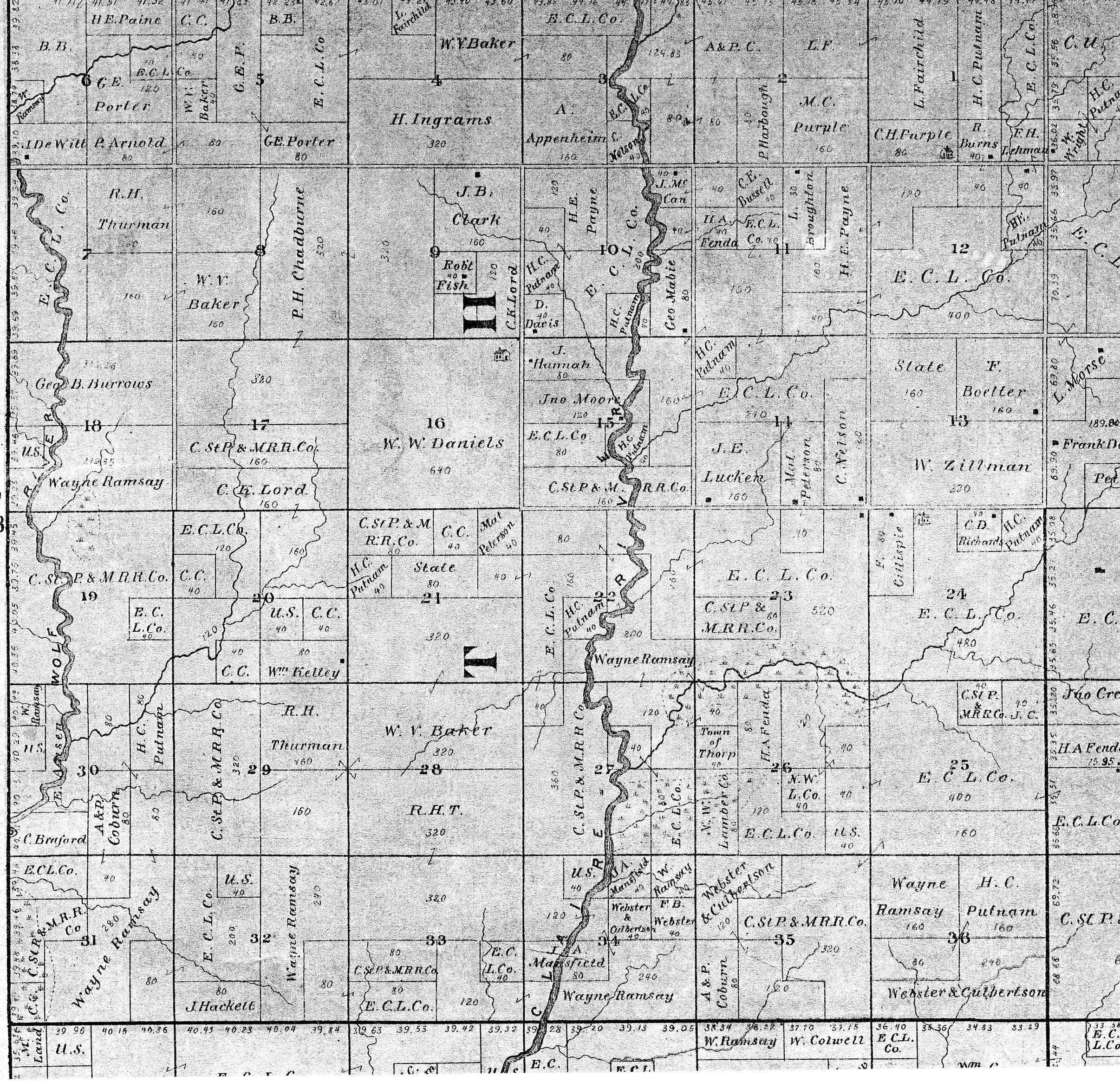
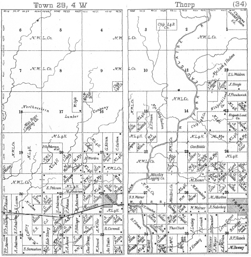
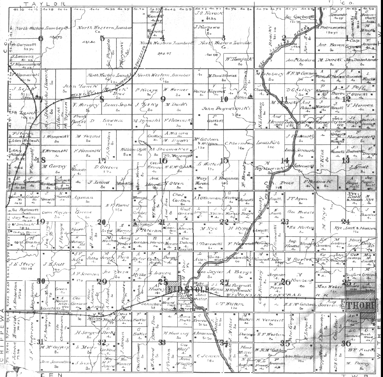
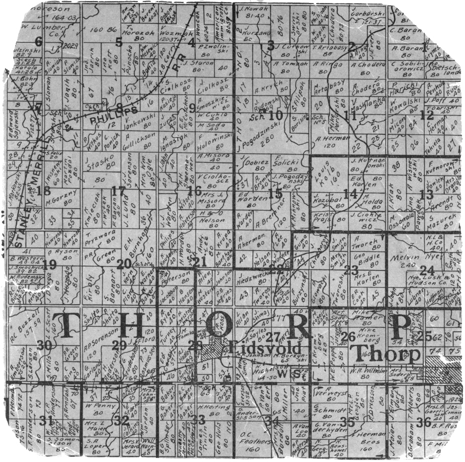
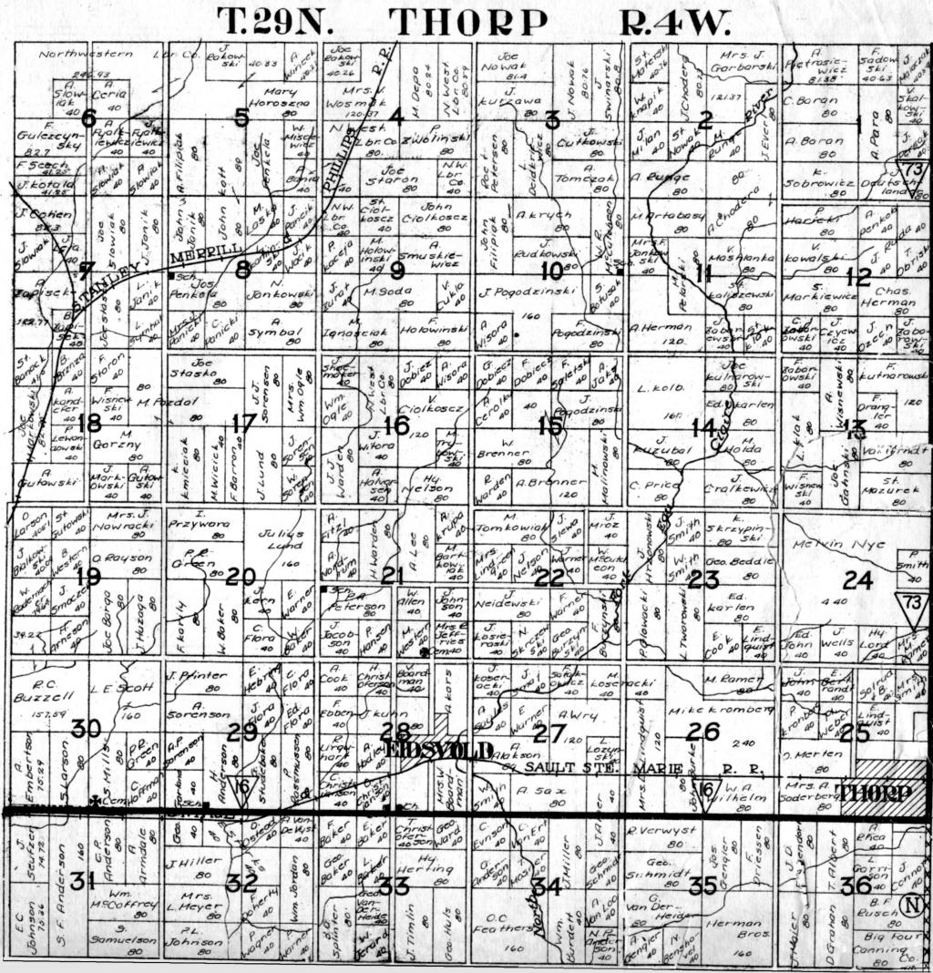
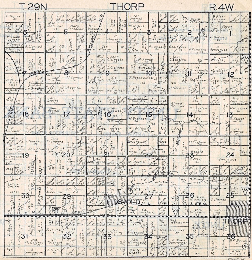
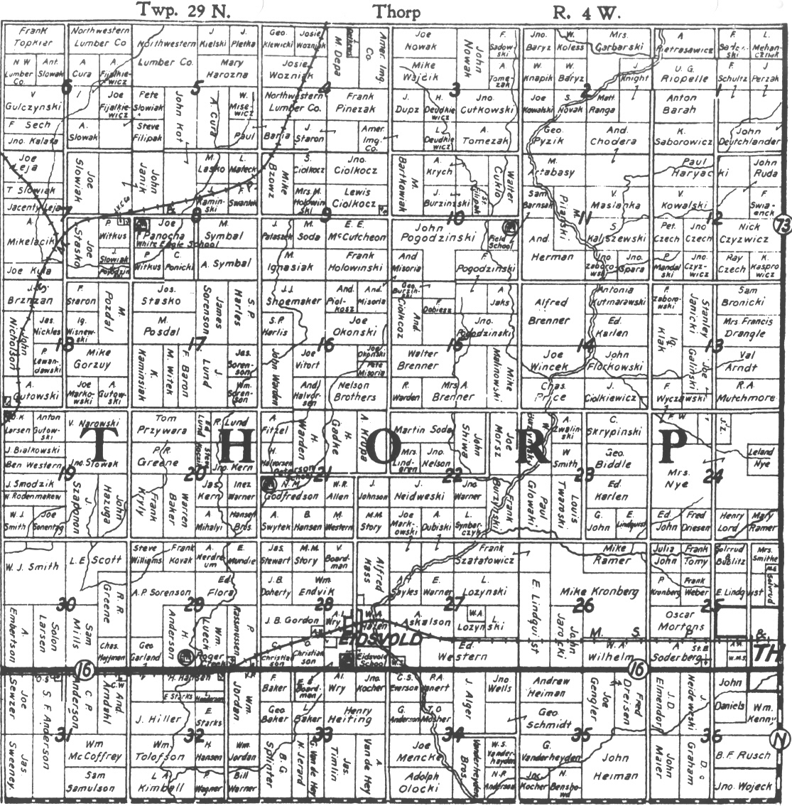
Plat Map Project

Because of copyright laws, we will not be able to display the actual maps which were produced after 1926 unless you are able to obtain permission for us to do so.

Plat Maps

  • Land Patents -- The records here are from 1866 to 1884. They are based on Land Patents which were obtained from the the Wisconsin Board of Commissioners of Public Lands, and transcribed by Paul Forster.
  • 1880 Plat Maps -- In 1880, the Town of Thorp was composed of the current town of Thorp and the current town of Worden. Both maps are very large (2-3 Mb); the 1880 map for the current town of Thorp is here, and the 1880 map for the current town of Worden is here.
    • Transcription for the sections comprising the current town of Thorp are here.
    • Transcription for the sections comprising the current town of Worden here.
    1893 Plat Map--Contributed by Alice Braun
    • Transcription by section:  All.
    • Listing by Property Owners: All (alphabetical listing)
  • 1905 Plat Map--By George. A. Ogle & Co., Chicago, IL (Contributed by Greenwood Public Library). 
    • Transcription by section:  All.
    • Listing by Property Owners: All (alphabetical listing)
  • 1915 Plat Map & Supplement of Additional Property Owners
              (This is an extremely rare map contributed by the Thorp Area Historical Society)
    • Transcription by section:  All.
  • 1917 Plat Map
    • Listing by Property Owners: All (alphabetical listing)
  •  1920 Plat Map (a large version of this scan is available upon request-it's over 2 MB)
  • new!1921 (ca.) Plat Map (origin unknown), provided by "The Jailhouse Museum".
  • 1926 Plat Map--By Standard Map Co., Chicago, IL (Contributed by Paulette Strey).
    • Transcription in progress
    • Listing by Property Owners: All (alphabetical listing)
  • 1936 Plat Map--*Standard Map Co, Chicago, IL *Can't be displayed because of Copyright restrictions and the date of this map is uncertain but it has been determined to be from after 1936, but before 1940. (Contributed by Owen Haigh).
    • Listing by Property Owners: All (alphabetical listing)
  • 1949 Plat Map
    • Listing by Property Owners: All (alphabetical listing)
  • 1956 Plat Map--By Rockford Map Publishers *Can't be displayed because of Copyright restrictions. (Contributed by Alice Braun)
    • Listing by Property Owners: All (alphabetical listing)
  • 1964 Plat Map--By Rockford Map Publishers *Can't be displayed because of Copyright restrictions. (Contributed by Alice Braun)
  • 1967 Plat Map
    • Listing by Property Owners: All (alphabetical listing)
  • 1970 Plat Map
    • Listing by Property Owners:All (alphabetical listing)
  • 1973 Plat Map
    • Listing by Property Owners: All (alphabetical listing)
  • 1976 Plat Map
    • Listing by Property Owners: All (alphabetical listing)
  • 1979 Plat Map
    • Listing by Property Owners: All (alphabetical listing)
  • 1988 Plat Map
    • Listing by Property Owners: All (alphabetical listing)
  • 1991 Plat Map
    • Listing by Property Owners: All (alphabetical listing)
  • 1994 Plat Map
    • Listing by Property Owners: All (alphabetical listing)
  • 2003 Plat Map
    • Listing by Property Owners: All (alphabetical listing)

Owners by Section Number

  • A listing of owners by section number across the above maps and years. This is a large chart that may take a minute or two to load.